As January 2025 unfolds, the eastern United States is bracing for one of the coldest winters in recent memory. Meteorologists are warning of an intense polar vortex that is set to plunge temperatures to historic lows, potentially making this the coldest January since 2014.

What is a Polar Vortex?
The polar vortex is a large area of low pressure and cold air surrounding the Earth’s poles. Occasionally, this vortex can weaken, causing frigid Arctic air to spill southward into regions that are typically milder during the winter months. This phenomenon is responsible for the bone-chilling temperatures and severe weather conditions currently gripping the eastern half of the United States.
Temperature Plunge: How Cold Will It Get?
The polar vortex is expected to bring temperatures plummeting to as much as 30 degrees below average in some areas. Cities like Chicago, Detroit, and Cleveland are preparing for subzero temperatures, while states in the Northeast, including New York and Pennsylvania, are experiencing icy conditions that could disrupt daily life. Even regions as far south as the Carolinas are not immune, with forecasters predicting unseasonably cold weather.
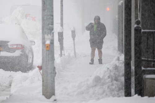
Impact on Daily Life
The extreme cold is already causing disruptions:
- Power Outages: Utility companies are warning residents to prepare for potential power outages due to the increased demand for electricity and potential damage to infrastructure from ice and snow.
- Transportation Chaos: Airports in major hubs like Boston, New York City, and Washington, D.C., are issuing travel advisories as heavy snowfall and icy runways threaten flight schedules. Roadways are equally treacherous, with authorities urging drivers to exercise caution or stay off the roads altogether.
- School Closures: Many school districts in the affected regions have announced closures or delays as temperatures drop to dangerous levels.
Snowstorm Alerts in the Northeast and Great Lakes
In addition to the frigid temperatures, the Northeast and Great Lakes regions are facing increased snowfall. Blizzard-like conditions are forecasted in some areas, with accumulations expected to exceed a foot in parts of upstate New York and northern Michigan. High winds are exacerbating the situation, creating whiteout conditions and increasing the risk of frostbite for anyone exposed to the elements.
How to Stay Safe
As the polar vortex continues to dominate weather patterns, experts urge residents to take precautions:
- Dress in Layers: Wear insulated and windproof outerwear, and cover exposed skin to prevent frostbite.
- Stock Emergency Supplies: Keep essentials like water, non-perishable food, flashlights, and blankets on hand in case of power outages.
- Avoid Outdoor Activities: Limit time spent outdoors and ensure pets are kept inside.
- Monitor Weather Updates: Stay informed by following local weather reports and updates from the National Weather Service.
Looking Ahead
While the polar vortex is causing widespread challenges, meteorologists suggest the Arctic blast could subside later in the month. However, until then, residents are urged to prepare for continued disruptions and to prioritize safety during this unprecedented winter event.